Overview
Status: Project Refinement

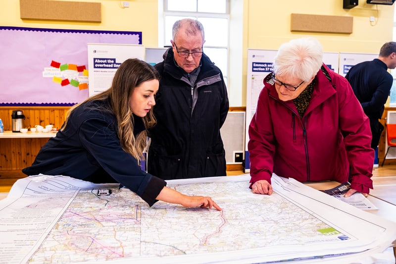
Black Bridge Replacement Public Consultation Events
We would like to thank all local community members and stakeholders who took the time to attend our recent public consultation events which took place on Thursday 4 December in relation to our proposed new Fanellan 400kV Substation and Converter Station should the development receive consent.
Our feedback period closed on Tuesday 13 January 2026 where we welcomed comments regarding our proposals to replace the Black Bridge near Kilmorack.
Although the formal feedback period has closed, we continue to welcome comments on how we can engage with you during the next phase of the project, you can provide this by getting in touch with us through either of the below methods;
Email: FanellanEngagement@sse.com
Post: SSEN Transmission, 10 Henderson Road, Inverness, IV1 1SN
The consultation materials remain available on our project webpage.
Energy Consents Unit validation of Section 37 application for Beauly-Denny OHL application
Our application has now been validated by the Scottish Government ECU. To find out how to view the application and submit comments please see project updates.
About the Project
In order to support the continued growth in onshore and offshore renewables across the north of Scotland, supporting the country's drive towards Net Zero, investment in network infrastructure is needed to connect this renewable power and transport it from source to areas of demand across the country.
Extensive studies have confirmed the need to reinforce the onshore transmission infrastructure between Spittal to Beauly and Beauly to Peterhead, the need for a subsea cable between Spittal and Peterhead, and a subsea/onshore cable between Beauly and the Western Isles.
To enable these reinforcements, a new 400kV substation is required within a 10km radius of Beauly and will connect to:
- A new Beauly Area HVDC Converter Station
- The existing Beauly/Wester Balblair 400kV Substation
- The existing Beauly - Denny 400kV Overhead Line
- A new 400kV connection between Spittal and Beauly
- A new 400kV connection between Beauly and Peterhead
Find Out More About Spittal - Loch Buidhe - Beauly 400kV Connection
Find Out More About Beauly - Blackhillock - New Deer - Peterhead 400kV Connection
This video outlines how the project contributes to our role in delivering Net Zero.
Pathway to 2030
The Pathway to 2030, published by National Energy System Operator NESO, the electricity system operator for Great Britain, sets the blueprint for the electricity transmission network infrastructure required to enable the forecasted growth in renewable electricity across Great Britain.
The projects identified within the Pathway to 2030 are critical to delivering the UK and Scottish Government’s offshore wind targets. To deliver these targets, we are investing over £10bn to upgrade the network infrastructure across the north of Scotland as the region plays a leading role in the clean energy transition.
As part of this investment, there is a requirement for a new 400kV substation in the Beauly area.
Stakeholder Engagement
The New Fanellan 400kV substation and Converter Station project is currently in the development stages and is subject to extensive consultation with stakeholders.
In this video, Rebecca Gay and Martin Godwin, Project Manager and Community Liaison Manager for the Spittal to Beauly Overhead Line Project, describe the approach we are taking in developing our proposals and the opportunities that are available for stakeholders to feed into the design process.
How we’re embracing artificial intelligence (AI)
We intend to use AI to assist our experienced teams in the analysis of your feedback, so we can categorise key points raised more quickly. You can learn more about how we’re utilising AI on this dedicated web page.
Project Updates
Featured updates
Featured updates for this project
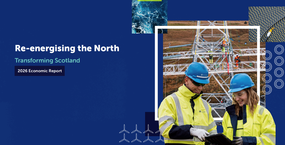
SSEN Transmission publishes new economic analysis highlighting transformative growth potential of £29bn grid investment programme

Water sampling works at the Black Bridge
Update on archaeological investigations at the proposed Fanellan site
Further update on ground investigation works near Black Bridge
Project updates
-
SSEN Transmission publishes new economic analysis highlighting transformative growth potential of £29bn grid investment programme
We have today published a new economic report setting out the significant economic benefits associated with our planned £29bn investment in new and upgraded electricity transmission infrastructure across the north of Scotland.
The report, titled ‘Re‑energising the North: Transforming Scotland’, provides an update on our previously outlined economic analysis on plans to invest billions in mission-critical grid infrastructure, providing further insight into the scale of economic opportunity associated with the investment programme.
The report reaffirms our programme as one of the largest private infrastructure investments in Scotland’s history, with around £29bn of planned investment across the north of Scotland in the next five years, and it details the extent of the economic opportunity across the region.Using advanced economic modelling to analyse the impact of clean power infrastructure investment, the report’s findings conclude that our investment:
- Will support up to 10,000 jobs in the north of Scotland, and 24,000 across Scotland;
- When added to investment by other transmission operators and investment in generation will add around £60bn to UK economic output - with the Scottish economy up to 3% larger over the long term;
- Will deliver long-term improvements in productivity, wages and economic resilience, with employees moving into higher-value roles and key sectors expanding permanently; and
- Will create unique opportunities for Scottish suppliers, businesses and communities across multiple sectors, including forestry, peatland restoration, aggregates and concrete too.
The findings highlight the importance of ensuring that the benefits of investment are felt locally, with thousands of skilled jobs, increased supply chain activity, and investment flowing into communities across the north of Scotland.
Read the full News and Views article to find out more.
Water sampling works at the Black Bridge
We will soon be carrying out a series of water sampling visits near the Black Bridge. This activity is a short, periodic monitoring exercise to gather additional information about ground conditions. It does not represent a restart of wider works and is limited to site monitoring only.
What to expect
Sampling will be undertaken by a single engineer and support operative using handheld equipment. The bridge will remain open with a single‑lane throughway in operation, managed by stop/go traffic management boards. Short temporary traffic holds will be required while sampling is undertaken and traffic moves safely through the area.
When the works are happening
There are a number of visits required for these works, with the dates outlined below:
- Thursday 18 June
- Thursday 2 July
- Thursday 16 July
- Thursday 30 July
Works are expected to take place at approximately 2pm on each date. The traffic management will be in place for approximately 15-30 minutes on each occurrence.
Please note that all dates and timings are indicative and may be subject to change. Traffic management will only be in place when required, and we will continue to provide updates on the project webpage as the works progress.
We will aim to keep disruption to a minimum and thank you for your patience while these works are carried out.
If you have any questions, please contact us via the Fanellan engagement mailbox at fanellanengagement@sse.com

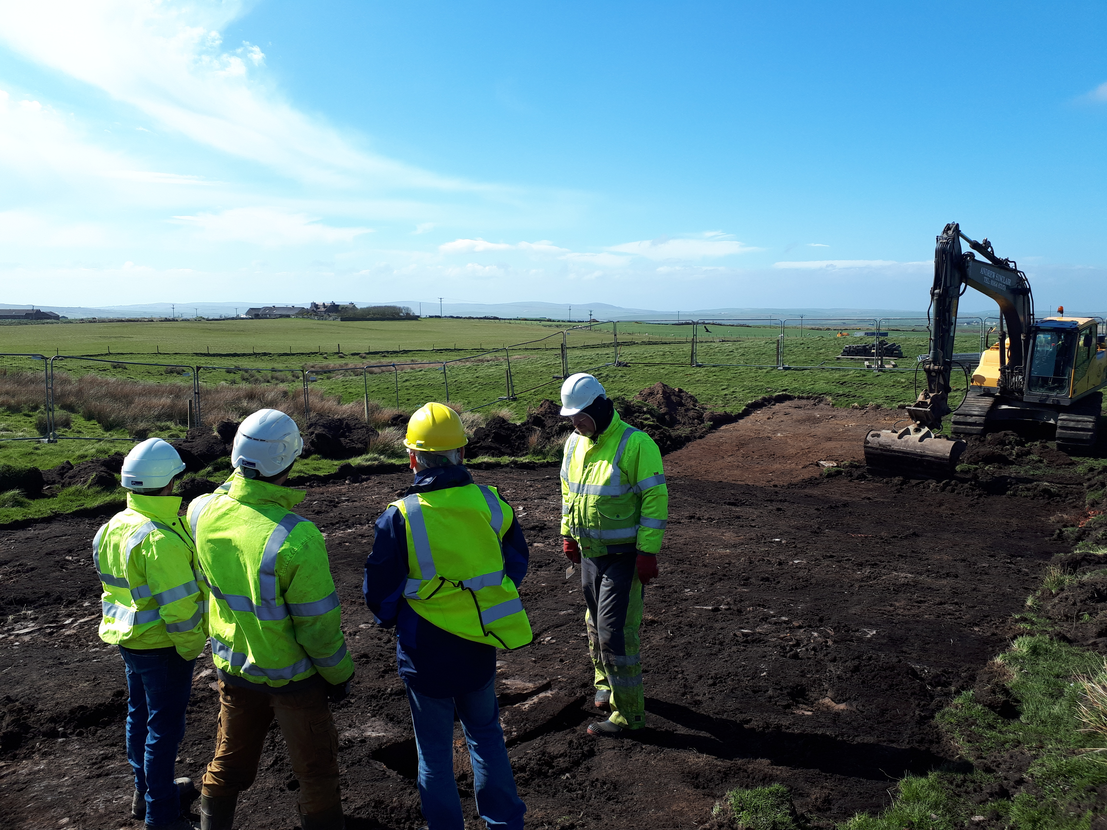
Update on archaeological investigations at the proposed Fanellan site
We are providing a further update on archaeological investigations currently underway at the proposed Fanellan 400kV substation and converter station site. As part of the ongoing archaeological process, a new scheme of investigation has been identified. All investigations are carried out under the oversight of The Highland Council’s Heritage Team. The works identified to date are expected to be completed by late summer 2026, although this timeframe necessarily remains indicative.
Why exact time frames cannot be provided:
Archaeological programmes are inherently uncertain, with the scope of investigations often informed by earlier findings. For that reason, it is not possible to confirm an exact completion date at this stage, and timeframes may change as investigations progress.
The archaeological activity on site remains temporary investigative works. The works are being carried out in accordance with the relevant permissions and agreed processes, under the oversight of The Highland Council’s Historic Environment Team and in consultation with ecology specialists. All land will be fully reinstated once these investigations are complete.
These works do not represent the start of construction, and they do not predetermine the outcome of the ongoing planning appeal. They are being undertaken at SSEN Transmission’s own risk and do not indicate or prejudge the outcome of the planning appeal. They are being undertaken to ensure that, should planning consent be granted, the necessary information is available to inform any future design, mitigation or construction planning.
Next steps:
Once the works have been finalised, and subject to the outcome of the planning process, there may be opportunities to welcome the local community to information events and support educational engagement in the area.
We will continue to keep local communities and stakeholders updated as this work progresses and will share further updates in due course.
If you have any questions, please contact us via the Fanellan engagement mailbox at fanellanengagement@sse.com
Black Bridge works: car park reinstatement and access update
Following our update issued 8 June, we are getting in touch to provide some additional detail on the current works programme at Black Bridge:
- Wednesday 10 June – Demobilisation of equipment will continue in the afternoon as previously planned and communicated. Equipment will be removed and transported through Kiltarlity under escort.
- Thursday 11 June – Additional stop/go boards will required to safely off-load and load equipment required for reinstating the car park and cemetery access track. Access will be managed via a stop/go system, with any traffic restrictions limited to up to 15 minutes at a time.
- Friday 12 June – The car park will be re-opened.
Timing may vary on the day depending on site progress. On Thursday 11 June, restrictions are expected to take place once at the start of the working day and once at the end. Consideration has been given to school transport when planning these activities.
Some flexibility may be required due to site conditions or weather. Updates will be posted on the project webpage as works progress, and any significant changes will be communicated directly.
There may also be occasional vehicle movements through Kiltarlity in the coming period, as we remove some site materials. These are limited in number and will be managed in line with agreed traffic arrangements.
If you have any questions, please contact the team via the Fanellan engagement mailbox at fanellan.engagement@sse.com.
Further update on ground investigation works near Black Bridge
We would like to provide a further update on the current works programme at Black Bridge.
Updated programme:
- Wednesday 10 June – South-side of Black Bridge – Stop/go boards will be required to facilitate the removal of equipment from the site.
This will result in short periods of restricted access, with delays of up to 15 minutes. All appropriate permissions are in place for these arrangements.The exact timing of these activities will depend on site progress on the day, however we anticipate these works to be carried out in the afternoon. Consideration will be given to school transport movements when planning and undertaking these works.
Following this activity, the car park on the south-side of the Black Bridge will then re-open on 12 June.
Further programme works:
As previously advised, further works on the north-side of Black Bridge, which were postponed, remain under review. A separate update will be issued once the revised programme for these activities has been finalised.
Equipment required for the postponed ground investigation works can be accommodated within the north-side working area and as such the car park will not be required for equipment storage.
Updates will continue to be published on the project webpage as works progress. Once dates are confirmed, these will also be communicated directly.
We appreciate your understanding and will keep you informed of any further developments.
If you have any questions, please contact us via the Fanellan engagement mailbox at fanellan.engagement@sse.com
Further update on ground investigation works near Black Bridge
We would like to provide a further update on the current works programme at Black Bridge.
Please note that the previously communicated activity scheduled for Tuesday 2 June, the equipment removal from the site, will no longer take place on this date.
It is currently anticipated that this will now take place during the week commencing Monday 8 June, and we will provide a further update once the exact date has been confirmed.
There will continue to be a requirement for traffic management, including stop/go boards, as part of this activity. All necessary permissions remain in place, and details will be updated once the revised programme is confirmed.
As previously communicated, further works on the north-side of Black Bridge are under review following earlier postponement. A separate update will be issued once the updated programme for these activities has been finalised.
Where traffic management is in operation, short delays may be experienced. The exact timing of these activities will depend on site progress on the day. Consideration will be given to school transport movements when planning and undertaking these works.
Some flexibility may be required depending on site conditions and weather. Updates will be published on the project webpage as works progress. Where there are significant changes to the programme or traffic management arrangements, these will be communicated directly.
If you have any questions, please contact us via the Fanellan engagement mailbox at fanellan.engagement@sse.com
-
Black Bridge Works Update – Temporary Traffic Management and Revised Schedule
We would like to advise that the works programme has been adjusted due to circumstances outwith our control.
Consequently, some activities will be deferred, and we are currently reviewing the programme to establish a revised schedule. We will share an updated timeline as soon as this has been finalised.
Please note that traffic management stop/go boards will still be required as part of the ongoing works at Black Bridge, and all appropriate permissions are in place for these arrangements. The dates are outlined below.
Current programme:
- Friday 22 May – North-side of Black Bridge - Stop/go boards single lane closure, for up to three hours.
- Tuesday 26 May – South-side of Black Bridge - Stop/go boards will be required to facilitate the loading and unloading of plant equipment, as well as associated works. This will result in short periods of restricted access. Between these movements, traffic will be managed as a single-lane closure, using stop/go boards.
- Tuesday 2 June – South-side of Black Bridge - stop/go boards required to facilitate equipment removal from the site, with a short period of restricted access.
- Wednesday 3 June – Postponed
Where restricted access is required to facilitate loading and unloading activities, delays of up to 15 minutes may occur.
The exact timing of these activities will depend on site progress on the day. Consideration will be given to school transport movements when planning and undertaking these works.
Some flexibility may be required depending on site conditions and weather. Updates will be published on the project webpage as works progress. Where there are significant changes to the programme or traffic management arrangements, these will be communicated directly.
Other notable updates:
In addition to the above, a large container is due to be removed from the site compound at Fanellan on 28 May and will require transport through Kiltarlity, with the lorry making a return trip on the same day.
We appreciate your understanding and will keep you informed of any further developments.
If you have any questions, please contact us via the Fanellan engagement mailbox at fanellan.engagement@sse.com
Stop Go Boards at Black Bridge
Following confirmation of upcoming equipment movements which require traffic to be controlled for short periods, please be advised that at these times, traffic will be managed using stop and go boards to allow for the safe unloading and loading of equipment in the vicinity of the works. This approach is necessary due to the size and nature of the equipment being moved and is in place to ensure the safety of both road users and the workforce on site. Traffic will be held for short periods while these activities are carried out, and there may be delays of up to 15 minutes.
This is currently expected to take place tomorrow (14 May) South side of Black Bridge (entrance to the car park)
In the coming weeks there will be other instances of stop and go boards being utilised, we’ll continue to keep our Project Updates section up to date regarding additional dates.
The exact timing of these activities will depend on site progress on the day. Consideration will be given to school transport movements when planning and undertaking these works.
Some flexibility may be required depending on site conditions and weather. Updates will be published on the project webpage as works progress. Where there are significant changes to the programme or traffic management arrangements, these will be communicated directly.
If you have any questions, please contact us via the Fanellan engagement mailbox at fanellan.engagement@sse.com
Further update on ground investigation works near Black Bridge
We are issuing a further update on traffic management arrangements associated with the ongoing ground investigation works near Black Bridge.
As part of these arrangements, an additional stop/go board will be in operation on Tuesday 12 May on the south side of the bridge.
As previously communicated, dates continue to be subject to change depending on site progress and weather conditions.
If you have any questions, please contact fanellanengagement@sse.com
-
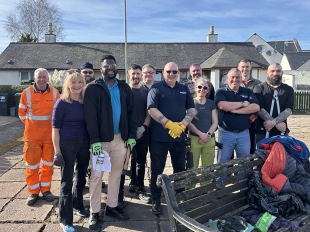
SSEN Transmission teams help spruce up community green spaces across Beauly
Local green spaces across Beauly have been given a welcome boost thanks to a community volunteering initiative delivered by teams from SSEN Transmission and their contractor Siemens BAM (SEBAM).
A combined team of around 25 volunteers swapped their usual tools for spades, shovels and rakes to help spruce up several community garden spaces throughout the village.
The volunteers represented both the ongoing Beauly 132kV Substation upgrade as well as development teams from the proposed Fanellan Substation project, delivering a coordinated programme of improvements designed to benefit the local community.
Read the full story here
Update on ground investigation works near Black Bridge
We are writing to provide a further update on the planned ground investigation works on the north and south sides of the River Beauly, near Black Bridge. Due to operational changes outside our control, we have had to update the programme for the planned ground investigation works in the Black Bridge area. The ground investigation works will now start from Monday 27 April 2026.
The temporary traffic lights arrangements remain unchanged from previous communications, but updated details of the stop and go board activity are set out below.
About the works
The works will remain the same. While the programme of works has changed, the overall duration remains as previously communicated and is subject to weather conditions and site progress.
During this time, a small team may be present on site, along with specialist equipment and some vehicle movements.
Update to the programme
Short‑duration lane closures will be required only for the loading and off‑loading of equipment. Each unloading activity is expected to last around 40 minutes, with stop and go boards in place.
The following dates are currently planned:
- South side of Black Bridge (entrance to the car park): 14 May
- South side of Black Bridge: 27 April
- North side of Black Bridge (between the A831 junction and the bridge): 18 May, 21 May, 26 May, 3 June
Rolling short duration stop and go boards will also be used throughout the duration of the works, only where required and only for the time needed to complete individual activities.
As previously communicated, a further single‑lane closure will be required, with traffic lights in place to manage traffic. This is still expected to start from 27 April 2026 and last for up to ten days.
Plant and equipment access to the south side of Black Bridge will be via Kiltarlity. This route is expected to have minimal impact, as vehicle movements will be limited and managed.
The car park on the south side of Black Bridge will be closed to parking for the duration of the works, with the agreement of the landowner. Access will be maintained to the cemetery and for the fishing syndicate to reach their bothy.
These works are being carried out under Class 40 permitted development rights for survey activities. The Highland Council has been informed of the works and the updated timeline.
Keeping you informed
Any updates will be published on the project webpage as works progress. Where there are significant changes to the programme or traffic management arrangements, these will be communicated directly.
If you have any questions about these works, please contact fanellanengagement@sse.com
Update on ground investigation works near Black Bridge
Due to operational constraints outwith our control, we have had to update the programme for the planned ground investigation works in the Black Bridge area. Works will now commence on Monday 27 April.
You may have noticed that we have not been in the area recently while this update was being finalised. The temporary traffic lights arrangement remains unchanged, and we will issue an updated programme for the stop/go boards in due course.
Black Bridge ground investigation works: programme update
A minor change has been made to the programme for the ground investigation works at Black Bridge. The start of all works has been moved back by one week, with works now due to begin on 20 April. All other dates within the previously outlined programme will remain unchanged.
Once works commence, the arrangements previously outlined for the ground investigation works, including use of the car park, will apply. Vehicular access directly to the cemetery and the fishy bothy will remain open.
We will continue to monitor activity on site and keep our communications under review as works progress. Please look out for any updates being posted on the Fanellan project page.
Upcoming Ground Investigation works near Black Bridge
Ground investigation works will be taking place on the north and south sides of the River Beauly, near Black Bridge.
This update sets out information about the ground investigation works that are planned, what they involve, and what people may notice while they are underway.
About the works
The works will involve a small specialist team carrying out surveys and drilling to collect ground information. These are temporary activities and will be completed in stages as the work progresses.
The works are currently expected to start from Monday 13 April and continue for approximately six to eight weeks, subject to weather conditions and site progress.
During this time, a small team may be present on site, along with specialist equipment and some vehicle movements.
Why these works are necessary
The ground investigation works are required to support ongoing design development for the proposed Black Bridge works. Collecting detailed information about ground conditions helps ensure that any future designs are safe and appropriate for the location.
These works are being carried out under Class 40 permitted development rights for survey activities. The Highland Council has been informed of the works.
What to expect
Short‑duration lane closures will be required only for the loading and offloading of equipment. Each unloading activity is expected to last around 40 minutes, with stop and go signs in place.
The following dates are currently planned:
- North side of Black Bridge (between the A831 junction and the bridge): 13 April
- North side of Black Bridge (entrance to core path): 22 April, 8 May and 12 May
- South side of Black Bridge (entrance to the car park): 13 May
- South side of Black Bridge: 2 June
A further single‑lane closure will be required, with traffic lights in place to manage traffic. This is expected to start from 27 April and last for up to ten days.
Plant equipment access to the south side of Black Bridge will be via Kiltarlity. This route is expected to have minimal impact, as vehicle movements will be limited and managed.
The car park on the south side of Black Bridge will be closed to parking for the duration of the works, with the agreement of the landowner. Access will be maintained for the cemetery and for the fishing syndicate to reach their bothy.
If there are any changes to the information above, updates will be provided.
If you have any questions about these specific works, please contact fanellanengagement@sse.com.
-
Survey works on the existing Beauly–Denny overhead line
We would like to make local communities aware of upcoming survey works on the existing Beauly–Denny overhead line in the Fanellan area. As access for the survey team will be taken from the Fanellan site, we are sharing this information so you are aware in case you notice activity in the area. Residents close to the works location have been informed.
What is happening
Contractors will be carrying out site investigation works around three of the existing Beauly – Denny towers. This will involve short-period excavation using a 5-tonne excavator, along with percolation testing to assess ground conditions. These investigations help our engineers understand the ground conditions needed for future restringing works. We expect minimal disruption, with brief periods of noise and occasional contractor or vehicle movements as the team moves between tower locations. All access for the works will be taken from the Fanellan site, but the activity relates solely to the existing overhead line.
When the work will take place
The works are planned to begin on 23 March 2026 and will continue for around two weeks, with a completion date of early April, subject to weather conditions. Activity will be limited to the tower foundations and the access routes between them.
If you have any questions or concerns, please contact us via the Fanellan Engagement mailbox fanellanengagement@sse.com -
Clarification on Continuation of Archaeology Works
We have received some enquiries regarding the ongoing archaeological surveys at the proposed Fanellan site and would like to provide some further clarity around the permissions and purpose of these works.
Archaeological investigations began on site at the end of 2025 and are being carried out under Class 40 permitted development rights, which allow statutory undertakers to undertake temporary ground investigation works with full reinstatement of the affected land to take place afterwards. All activities were agreed in advance with the Highland Council’s archaeological team, and findings are being reported through the Archaeological Clerk of Works.
It is currently anticipated that these surveys will continue to late Spring. In the event they are required to continue beyond then, we will ensure that stakeholders are updated accordingly.
As previously communicated, we would like to further reassure stakeholders that the continuation of these surveys should not be viewed as a predetermination of the appeal process.
Throughout this process, our commitment to open, positive and constructive engagement with local communities and stakeholders remains unchanged.
We appreciate that people hold different views on the project, and we are committed to continuing transparent dialogue and providing regular updates.
A further update on these surveys will be shared in April.
Please do get in touch if you have any questions.
Proposed Fanellan - project update
Following the recent decision by the Highland Council’s South Planning Committee to refuse the proposed Fanellan project, we wanted to share some additional context and reassurance about pre-construction investigatory works that continue on site.
Whilst we are naturally disappointed by the Committee’s decision, particularly given it went against the recommendation of the Council’s Planning team, we can confirm that we intend to appeal the decision to the Scottish Government’s Department for Planning and Environmental Appeals.
In the meantime, the investigatory activities on site that began before Christmas are intended to continue, with archaeological surveys due to progress over the coming months. The conclusion of these works is required prior to the commencement of main construction works, should planning consent be granted following an appeal process.
Separately, we also continue to develop the proposed design for the replacement of Black Bridge, taking into account the feedback received during the statutory consultation event of December 2025. Again, should consent be granted for the substation following appeal, the replacement of the Black Bridge will be required to support the transportation of certain key components to site.
We anticipate holding the second Pre Application Consultation event in late spring 2026, and will confirm dates as soon as they are finalised.
Why we are continuing these works
The continuation of these surveys and consultation events are not considered to be a pre-determination of the appeal process, rather more that should the appeal be granted, we need to be able to progress the construction works efficiently and this is therefore being undertaken at SSENT`s risk. They will help ensure that we have accurate information to support any potential design changes, mitigation measures or future planning/construction considerations.
Pausing certain works at this point would also risk having to repeat specialist work later if consent is granted, so completing them now ensures we maintain efficiency without advancing any irreversible work.
Throughout this process, our commitment to open, positive and constructive engagement with local communities and stakeholders remains unchanged.
We appreciate that people hold different views on the project, and we are committed to continuing transparent dialogue and providing regular updates.
Please do get in touch if you have any questions
FanellanEngagement@sse.com -
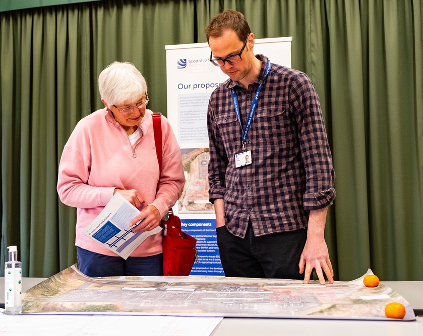
Black Bridge Replacement Public Consultation Events
We would like to thank all local community members and stakeholders who took the time to attend our recent public consultation events which took place on Thursday 4 December in relation to our proposed new Fanellan 400kV Substation and Converter Station should the development receive consent.
Our feedback period closed on Tuesday 13 January 2026 where we welcomed comments regarding our proposals to replace the Black Bridge near Kilmorack.
Although the formal feedback period has closed, we continue to welcome comments on how we can engage with you during the next phase of the project, you can provide this by getting in touch with us through either of the below methods;
Email: FanellanEngagement@sse.com
Post: SSEN Transmission, 10 Henderson Road, Inverness, IV1 1SN
The consultation materials remain available on our project webpage.

Notification of Upcoming Escorted Vehicle Movements Through Kiltarlity Village
We would like to inform you of upcoming escorted vehicle movements scheduled to travel through Kiltarlity village.
The Highland Council will be visiting the Fanellan site on Monday, 19 January 2026, and to support this visit a machine will be transported to site to demonstrate heights and levels. These vehicle movements will be escorted as outlined below:
Friday, 16th January 2026
- One escorted low loader will transport a boom lift to the Fanellan site in preparation for the visit from The Highland Council Councillors on Monday, 19 January 2026.
Monday, 19 January 2026
- One escorted low loader will transport the boom lift from the Fanellan site following the Council visit.
We do not anticipate any disruption to the local community as a result of these movements. The contractor has been advised of local school drop off and collection times and will plan vehicle movements to avoid these busy periods wherever possible.
-
Update re the proposed Fanellan project
Update re the proposed Fanellan project
Site Closure and Re-Opening
- The site closed on Friday 19th December and will re-open on the morning of 5th January 2026. There will be no generators running over this period.
- A small team will be on site on Sunday, 4th January to re-plumb and refuel equipment, ensuring a safe return for the workforce.
Security Measures- security cameras have always been present on site, the cameras have been upgraded
- A CCTV mast has been erected in the site compound.
- Additional CCTV towers have been installed for enhanced security: one in the site compound and one at the farmer’s yard.
- Occasional security/safety visits to the site may be conducted throughout the festive period by our contractors
January Work Programme
- Archaeology surveys will re- commence w/c 5th January . Please see additional information below.
- This will be supported by 4 excavators, 1 dozer, and the necessary management team. The most part of the surveys will be hand digging, therefore noise impacts are anticipated to be negligible.
- Topographical & GPR Survey on the A833 at the entrance to Beaufort Estate
Mitigating noise impacts in January
- Noise monitoring will be erected within the compound on both East and West sides.
- Acoustic barriers will be erected to minimise noise from generators while running.
Travel Arrangements
Car sharing and public transport is utilised to minimise impact on local communities.
Additional Updates - re Archaeology/Heritage surveys
Following the review of the first phase of surveys undertaken in accordance with The Highland Council Historic Environment Team (THC HET), further heritage features have been recorded that require more detailed assessment during Phase 2.
This additional scope has been agreed with The Council.
To ensure these works are completed as soon as practicable, we will be deploying additional archaeologists and supervisors to site. Consequently, further welfare provisions are required.
The site team are looking to complete these site surveys as soon as practicable.
The archaeology/heritage surveys will recommence in 2026 after the festive break. We are currently working up a programme to completion, but this will ultimately depend on what is found and availability of archaeologists, so it can be difficult to provide an accurate programme for their completion. Current working arrangements are between Monday to Friday and is largely hand digging. As such, we anticipate minimal disruption to the local community resulting from these surveys.
SSEN Transmission - Upcoming Works and Plant Movements – A833 Area
Please see update on some ongoing and upcoming works and associated plant movements in the A833 area associated with SSEN Transmission’s Fanellan project: New Fanellan 400kV substation and Converter Station - SSEN Transmission
- Archaeological Works – Fanellan Site
- Reason: Recent archaeological findings require the team to stay on site longer and additional welfare facilities to be provided.
- Additional Machinery: 6 units
- Dates: 15/12/25 – 18/12/25
- Travel Route: Escorted through Kiltarlity
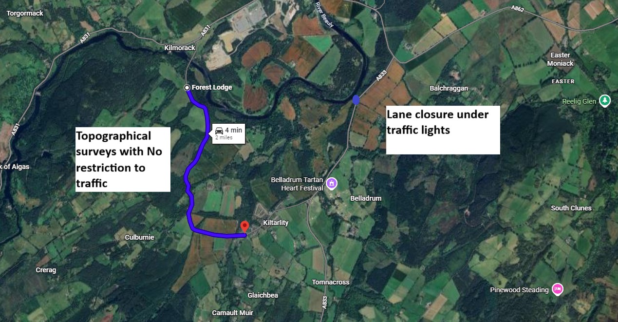
- Topographical Survey – C1106 to Fanellan Road Junction
- Purpose: establish existing road and drainage level and Surveyors will record land levels and coordinates using GNSS equipment.
- Area: See attached map
- Dates:
- 10/12/25 – 12/12/25
- 15/12/25 – 19/12/25
- Road Management: One surveyor will act as a lookout and ensure safety by moving to a safe spot when vehicles pass.
- Topographical & GPR Survey on the A833 at the entrance to Beaufort Estate
Purpose: To establish existing road and drainage level and Surveyors will record land levels and coordinates using satellite equipment.
- Dates: 12/01/26 – 16/01/26
- Road Management: Temporary traffic lights will be in place.
Please note that sometimes dates may change due to circumstances beyond our contractor’s control, however they will endeavour to stagger vehicle movements where possible and scheduled outside school drop-off and pick-up times.
If you have any questions please email: FanellanEngagement@sse.com
-
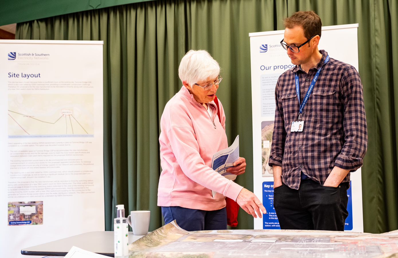
Black Bridge Replacement Public Consultation Events
We invite local residents and stakeholders to attend the first of two rounds of statutory pre-application (PAC) consultation events for our proposals to replace the Black Bridge near Kilmorack.
These proposals are in relation to our proposed new Fanellan 400kV Substation and Converter Station should the development receive consent.
Consultation events will take place on:
Thursday 4 December, 11.45–2.15pm, Phipps Hall, Beauly, IV4 7EH
and
Thursday 4 December, 4–6.45pm, Kiltarlity Village Hall, IV4 7HH
Please note that the Beaufort Access Track will not form part of the consultation event as initially advertised. Development of the project is ongoing and therefore has not reached a stage suitable for external consultation.
-
SSEN Transmission Investigation Works Update – Beauly Area
Specialist Excavation Works – Proposed Fanellan Site
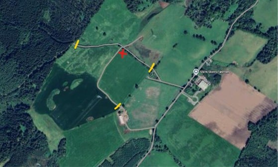
Specialist excavation works required as part of ground investigations at the proposed Fanellan site will include a trial for ‘blasting’, a controlled technique used to break up materials to allow for excavation. This is a standard method in infrastructure development, designed to assess any potential impact on nearby structures and ensure full compliance with safety standards.
Following excavations at site to expose rockhead throughout W/C 20 October, deliveries to site are due to be undertaken early in the W/C 27 October.
- Deliveries of plant and materials 27 and 28 October; a drill rig and aggregate (27) and materials (28); escorted via Kiltarlity.
- Trial blast date; Tuesday 28 October
- Rig removed from site; Wednesday 29 October; escorted via Kiltarlity.
During the trial, you may notice a short, sharp noise, minor ground vibrations within close proximity to the site and visible safety signage and personnelThe trial blast will take place in the area marked with a red cross on the site plan and staff will be present indicated by the yellow marks on the map to stop anyone inadvertently accessing the area.
Following the trial, further specialist excavations are due to take place in the following weeks, and we’ll write to you to provide further information once available.
Specialist Excavation Works – Trial Location
Investigation Works on A833 near Beaufort Estate
Following our recent announcement regarding the agreement with Beaufort estate which would see construction traffic directed through the estate grounds, investigation works are scheduled to begin Tuesday 21 October on the A833 adjacent to Beaufort Estate.
The works will involve hand digging trial holes and will be carried out under a phased single-lane closure, managed by temporary traffic lights. The investigation is expected to take approximately 5 days to complete.
Please find below a map showing the location of the works, marked in red.
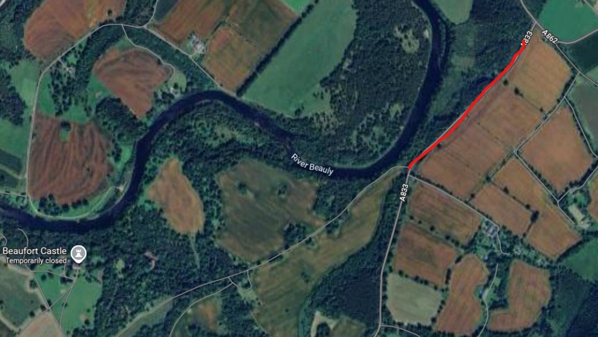
A833 Investigation Works LocationLIDAR Surveys for proposed Spittal – Beauly Overhead Line
Preparatory LIDAR (Light Detection and Ranging) works have recently commenced around Beauly, with teams installing ground control points—small, marked spots on roads—to help improve GPS accuracy when survey vehicles later map the area, allowing for further contractor assessment of roads and tracks.
The team will be continuing these works northward throughout the coming weeks, with LIDAR surveys between Beauly and Loch Buidhe anticipated to be completed by the end of the month, although timescales are subject to change.
Please be assured that all works outlined in this update fall under permitted development rights and are fully compliant with all relevant planning and environmental regulations.
We appreciate your understanding and cooperation whilst these investigation works continue. If you have any questions or concerns, please don’t hesitate to contact us at Fanellan.engagement@sse.com.
Proposed New Construction Traffic Route for Fanellan Development
Following feedback from the local community, SSEN Transmission has proposed a new construction traffic route that would significantly reduce the impact on the village of Kiltarlity. An agreement has been reached with the Beaufort Estate to direct the majority of construction traffic through the estate grounds, effectively bypassing the village.
Read the full press release here: SSEN Transmission proposes new construction traffic route for Fanellan substation, reducing impact on Kiltarlity - SSEN TransmissionThis proposal has been submitted as an update to the Environmental Impact Assessment (EIA) supporting the Planning application, and forms part of a wider package of traffic mitigation measures.
As such, the Highland Council have re-opened their consultation period for the Fanellan Planning application, and will advise of consultation dates within their Planning portal and in a public notice, which will contain further information.
The additional documents can be found within the Planning application on the Highland Council’s website using application reference number 25/00826/FUL. The application can also be viewed by appointment between 9am - 5pm, Monday to Friday at the Infrastructure, Environment and Economy Service, Council Headquarters, Glenurquhart Road, Inverness, IV3 5NX and between opening hours at Kiltarlity Post Office.
You can also view the supplementary information from the ‘Documents’ section on the SSEN Transmission Fanellan webpage.
We will continue to work with the Highland Council to explore long-term solutions, including the potential replacement of the Black Bridge, which could serve as the main route for transformer deliveries scheduled for 2029.
-
Update on archaeological investigation works
We would like to update you on the archaeological investigation works currently underway site-wide within the boundary area of the proposed Fanellan site, these are programmed to continue to the end of the year.
All works are conducted under our Permitted Development Rights as a Statutory Undertaker and are essential to assess the potential presence of archaeological remains, such as ancient settlements, artefacts, or burial sites. The extent of the investigations has been agreed with The Highland Council.
As part of these, from the week of 8th September, work will also be in Butlers field and the adjacent field. A rubber tyred excavator in lieu of the previous tracked excavator will be used to help mitigate track noise and will also alleviate construction traffic off the track entrance. It will be moving between these two areas. Fencing is to be erected in the field opposite Butlers field, An approximate duration for these is 3 weeks.
Site Compound and Traffic ManagementAs previously advised, we are continuing to use our existing compound for this phase of work to minimise traffic through the local area.
Working HoursThere will not be any plant operation or excavation work out with 8am-1800hrs Monday to Friday. Staff may arrive at the compound before 8:00am and additional `SLOW` and `Children Crossing` signs will be erected to remind all road users to travel with care. The Contractor will also be including safety talks within their Toolbox talks.
Trial Blast – PostponedWe previously advised that a short trial blast was due to commence during the week of 15th September. This has now been postponed. We will provide an update once a new date is confirmed.
Ongoing CommunicationPlease note that all activities remain subject to change, depending on ground conditions and findings. We will continue provide updates of any changes which may impact the community/residents.
If you have any questions or concerns, please don’t hesitate to contact us at:Fanellan.Engagement@sse.com -
ECU Validation of Section 37 application for Beauly to Denny overhead line permanent diversion
Validation of SSEN Transmission`s Section 37 application to the Scottish Government’s Energy Consents Unit (ECU) for the Beauly to Denny OHL permanent diversion.
Under Section 37 of the Electricity Act 1989, the application is seeking consent to permanently divert a section of the existing 400 kV overhead transmission line (OHL) between Beauly and Denny, to install and keep approximately 1.7 km of overhead line supported on steel towers, and tie into a proposed new 400 kV Substation and Converter Station at Fanellan (planning application reference 25/00826/FUL). This application for consent under Section 37 of the Electricity Act 1989 also covers a temporary diversion of part of the OHL which will be needed to facilitate construction of the permanent OHL diversion works and the proposed new 400 kV Fanellan Substation and Converter Station.
The OHL diversions will be located approximately 5 km south-west of Beauly near Inverness (OS Grid Reference NH 48201 43005).
Viewing the application:
Our application has now been validated by the Scottish Government’s Energy Consents Unit (ECU) and can be viewed in full.
If you wish to view the Section 37 application and submit formal comment to the Scottish Ministers, it is available on the Energy Consents Unit’s website: www.energyconsents.scot The application reference is: ECU00005056
All the documentation submitted as part of the application can also be viewed and downloaded via our dedicated project website in the coming days.
A hard copy of the application location map can be viewed at the following location in the next day onwards.
Location Opening Hours Address Kiltarlity Post Office, Coffee Shop and Village Store Monday to Friday 07:30am to 4:30pm
Saturday 07:30am to 2:30pm
Sunday 08:30am to 4:30 pmAllarburn Place, Kiltarlity, Beauly, IV4 7HG Copies of a short Non-Technical Summary for the Environmental Appraisal can be made available (free of charge on request).
Submitting comments:
Any representations in respect of the application may be submitted via;
- the Energy Consents Unit website at energyconsents.scot/Register.aspx;
- by email to the Scottish Government, Energy Consents Unit mailbox at representations@gov.scot; or
- by post to the Scottish Government, Energy Consents Unit, 4th Floor, 5 Atlantic Quay, 150 Broomielaw, Glasgow, G2 8LU, identifying the proposal and specifying the grounds for representation. Please note that there may be a delay in the Energy Consents Unit receiving representations by post.
All formal representations regarding the application need to be sent directly to the ECU and should not be sent to SSEN Transmission. Please note that we cannot send these to ECU on your behalf.
Advertising and Questions:
Alongside this email notification we will also issue a formal public advert, updates on this application will be shared on our New Fanellan 400kV substation and Converter Station - SSEN Transmission.
Please contact the ECU if you have any questions on the application documents themselves. Once the application has been submitted SSEN Transmission is no longer able to engage in technical discussions, or answer queries specific to the application. All queries must be directed through the ECU.
Notification re Black Bridge Road closure – 19th-20th August and Diversion Information
We are writing to inform you about upcoming bearing inspection works required on the Black Bridge which will result in a temporary road closure over the bridge. Following feedback from Kiltarlity Community Council, it has been decided that an overnight 8-hour road closure is preferred rather than shorter frequent closures. Therefore, the road will be closed from 10pm on Tuesday 19th August to 6am Wednesday 20th August.
Please be assured that the road will be re-opened in plenty of time for the school run.
Our principal contractor, BAM will be carrying out the work. To support local traffic planning, clear signage indicating the road closure and diversion routes will be in place from 12th August to raise awareness of this closure.
We encourage all members of the community to review the attached file for details of the diversion routes and plan their alternative journeys accordingly.
Important Note: In the event of an emergency, works will be suspended immediately, and the road will be re-opened to allow emergency vehicle access.
Information about the proposed Fanellan project is available on the project webpage New Fanellan 400kV substation and Converter Station - SSEN Transmission
Please see road closure mapPlease do get in touch via the project mailbox if you have any questions.
Thank you for your cooperation and understanding
Storm Floris clean-up
As soon as Storm Floris subsided some of the project team were out cleaning up a number of large branches on the Fanellan road, this was followed by the mechanical road sweeper removing the remaining storm debris to ensure safe accessibility and travel for all road users.
-
End of initial phase of ground investigation works
The initial phase of ground investigation works for the proposed Fanellan project will be completed at the end of week commencing 21 July 2025.
We would like to thank the local community for their cooperation and understanding during this phase of works.
Next week there will be some demobilisation of containers where lorries with trailers will be travelling through Kiltarlity. We do not foresee any major disruption to the local traffic network. However, the cabins in the site compound will remain for the next phase of investigations, this is to minimise any traffic disruption in the local area and to prevent unnecessary traffic movement back and forth through Kiltarlity.
There will be an ongoing site presence for security reasons over the coming months.
This next phase of site investigations will start in September 2025, and further information will be shared in advance of these.`
-
Survey and Inspection works week commencing 6 May 2025
Further survey and inspection works are being carried out in the coming weeks in the Kiltarlity area. This will help inform the developing traffic management plan for the proposed Fanellan project.
There will be some non-intrusive surveys and inspections in the Kiltarlity area which we hope to start on the 6/5/25, and there are others as explained below which required traffic management.
These works are being planned and sequenced in the order listed below and inspected one site at a time to minimise any disruption to road users. There will not be any weekend working, but traffic maybe controlled with traffic lights for safety purposes.
When inspection works will be carried out
We propose to carry out the surveys to the structure that require traffic management to be in place between the12th May 2025 and the 16th June 2025. Specific details regarding traffic management have been provided below.
Areas where there may be short delays with traffic management in place.
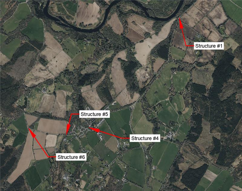
Structure 1 - Inspections will be carried out on a section of the retaining wall alongside the A833 from the A862. This requires STOP/GO signs for 1 day only on the 9/5/25.
Structure 4 - Allerburn Bridge in Kiltarlity– Inspection works will take approximately three weeks to complete . This will involve reducing the carriageway to one lane with traffic light control in place between 12/5/25 and 26/5/25.
Structure 5 - Bruich Bridge – Inspection works will take approximately 1 week to complete, and road narrowing traffic management will be required, though normal traffic flow will be maintained. This will be in place from 28/5/25 to 5/6/25.
Structure 6 - Allt Coiche Bridge – This inspection will take approximately 1 week and will involve reducing the carriageway to one lane with traffic light control in place from 9/6/25 to 16/6/25.
Every effort will be made to reduce the above timescales in each location.
Please allow extra time for your journeys as there will be short delays while this traffic management is in place, and we apologise in advance for any inconvenience this may cause.
-
We're here to lend a helping hand
We are committed to supporting the communities in the north of Scotland where we operate, both now and in the future. As part of our ongoing efforts to make a difference and have a positive impact on local communities, we are proud to offer volunteering days to local groups and charities, particularly in the areas that host our electricity infrastructure or where our proposed projects are located.
This month, we’re excited to announce the launch of our new Volunteering Webpage, designed to make it easier for local communities to request volunteering support from us. To request our help, simply complete the ‘Volunteering Nomination Form’ linked at the bottom of our new webpage. Please note, as our team works on a voluntary basis, it may take us some time to coordinate our people and match them with opportunities. We kindly ask for your patience as we work to keep up with volunteering demand.
Thank you for considering SSEN Transmission as a partner in your community efforts. Together, we can leave a positive, lasting legacy and help transform communities across the north of Scotland.

Proposed Fanellan project: Notification of increased construction traffic
Our principal Contractor SiemensBam have informed us that they need to increase the size of their work compound while the ground investigation works are being carried out.
Therefore, from this week onwards until Friday 28th February, there will be an increase in construction traffic in the area while additional site cabins, plant and aggregate are brought to site to carry out this work. Where required larger plant will be escorted and will travel from A833 through Kiltarlity village, turn right before Culburnie and travel onwards, turning left at the Fanellan junction up to the site compound beside the bottling plant. Please see map below.
Plant will be demobilised on Thursday 27th and Friday 28th February.
To minimise any local impacts the contractor will carry out these deliveries after 9.30am and avoiding times between 3pm-4.15pm and between 12-1pm on Fridays.
We anticipate minimal impacts from these traffic movements.

Black Bridge - Removal of drill rig - 7 Feb
Following completion of recent Ground Investigation works at the Black Bridge, we and SiemensBam have submitted a Road Works notification via the Scottish Road Works Register (SRWR) Aurora system to notify the Council of the planned works.Our traffic management contractor is liaising with the local road's inspector on the traffic management plans.
The drill rig to be removed on Friday 07 February subject to approval of the required Notice submitted.The removal of this rig by a low loader will take approximately 30 minutes and this is planned sometime between 9.30am-11.30am on Friday to avoid peak morning traffic.
From the A833 the low-loader will be escorted through Kiltarlity village , where it will then turn right along the road before Culburnie heading in the direction of the Fanellan junction. At the junction it will turn and then reverse to Black Bridge for the rig to be uplifted and will then exit the area along the same route. There may be several minutes delay at the junction area and when the rig is uplifted, though we are aiming to cause minimal delays.
Traffic management will be in place, and residents along the route will maintain full access to their properties. Road users will also, under traffic management be able to pass by the loader/loader and rig when it is safe to do so, though there may be very short delays at such times if it is not safe to pass.
Patience is appreciated during any short delays while the safe removal of the drilling rig can be carried out.
Overhead Line Local Engagement Events - Feb/March '25
We will shortly be hosting a series of public consultation feedback events across both project the Spittal - Beauly and Beauly - Peterhead overhead line project routes from 17 February until 6 March 2025.
Both new overhead lines would connect into the proposed new Fanellan Substation.
These events conclude the Pre-Application Consultation (PAC) process for the consent application that we aim to submit for both overhead line Proposed Developments to the Energy Consents Unit of the Scottish Government in Spring 2025.
For a full list of venues, please visit our Events - SSEN Transmission page.
During the Kiltarlity (19 Feb) and Beauly (20 Feb) events, members of the Fanellan project team will be on hand to help answer any questions you may have about the upcoming Fanellan 400kV Substation and Converter station consent submission. -

Notification of ground investigation works and environmental surveys on mainland cable route over the coming months
As part of the proposed Western Isles HVDC project SSEN Transmission are required to carry out further Ground Investigation (GI) and environmental survey works along the mainland cable route which will connect the proposed substation/converter station project on Lewis to the proposed substation/converter station project at Fanellan near Beauly.
The GI work is due to start w/c 27th January off a section of the A832 near Dundonnell and is expected to take approximately 2 weeks. Traffic management will be in place and there may be short delays to your journey. The works will involve the use of specialist plant and equipment to determine underlying ground conditions. Further ground investigations will be carried out on different sections of the route over the coming months.
We apologise for any inconvenience these may cause.
Please see the map below which shows the mainland cable route in green.
The environmental survey works are due to commence shortly and will involve non-intrusive visual inspection of the whole route by small teams of environmental specialists on foot. These works are expected to take 2 weeks.
If you have any queries about this work, please do not hesitate to contact the Community Liaison Managers for this project. -
Update - Proposed Fanellan project - December 2024
We are getting in touch to provide an update on the proposed new substation and converter station at Fanellan. The formal consultation process ended in the Summer and since then further survey and investigative works have and are being carried out to further inform the final design. It is anticipated that SSEN Transmission will submit the Planning Application early in the New Year.
We will keep you informed and let you know when the application is on The Highland Council portal for viewing, downloading documents and submitting comments.
Below is a summary of activities that have been taking place and ones that are planned in the coming months:
Black Bridge ground investigation works
These works to assess the condition of the Black Bridge began in November and are now scheduled to be completed in January. Should the proposed Fanellan project be consented, a key part of the construction strategy will be a traffic management plan to be agreed with The Highland Council ahead of construction works.
Due to the deteriorating bridge condition SSEN Transmission proposes to replace the bridge to ensure it can safely withstand the weight and extent of vehicle movement to and from site at the same time as ensuring access for other heavy vehicles for the community, such as fuel delivery and farm machinery and so on. More details regarding these proposals will be shared in the New Year, following completion of the ground investigation works.
In our most recent update regarding these works, it was stated that if weekend working had been agreed by local Community Councils, the duration of the Siemens Bam works were anticipated to reduce to 5 weeks as opposed to 7 weeks. However, the communication sent to the Community Councillors seeking their opinion on potential weekend working and the potential impacts, failed to outline the expected duration of these reduced timescales. For this we would like to apologise.
The team are demobilising this week and due to harder than anticipated ground conditions, will now require to return in the New Year (anticipated w/c 6th January) to complete the remaining investigation works and carry out reinstatement works towards the end of January.
Ground investigation works at Fanellan within the red line boundary area
Ground investigation works to determine ground conditions for final design and program refinement within the red line boundary area are being carried out by SBAM, our principal contractor. Taking place off public roads and on private land these works commenced week of 9th December, running until 20th December. They will resume during the week of 6th January and are expected to be completed in May.
In the New Year there will also be some local ground investigation works due to be carried out by the Spittal – Beauly and Beauly – Peterhead Overhead Line project teams.
We appreciate that these investigative works can at times impact those living and working in the area, we do try to ensure that that impacts are kept to a minimum and apologise for any inconvenience the works may cause.
Opportunity to ask outstanding questions
We are planning to hold informal sessions following the planning application which is programmed for submission in the New Year. Dates are to be confirmed. The aim of these sessions is to provide the opportunity for community members and other interested stakeholders to ask any outstanding project related questions to members of the project team about the project and subsequent planning application. A notification detailing dates and times will be shared in the New Year.
Finally, the Fanellan Engagement email box will be checked intermittently over the Xmas holiday period. We return to business on 6 January and will respond to any outstanding emails as soon after that as possible.
Wishing you a happy Festive period.
-
Update - possible temporary Black Bridge Closure
Notification sent to Community Councils 16th September 2024
Dear Community Councillors
Update - possible temporary Black Bridge Closure
As you will be aware we have received emails from community members expressing their concerns and objections to the possible temporary closure of the Black Bridge to allow for ground investigation works to assess requirements for a bridge replacement.
Should the substation receive planning consent, a key part of this construction strategy will be a traffic management plan, to be agreed ahead of construction works with The Highland Council. This will include the transportation of vehicles to and from site, including key substation components, many of which will require heavy load vehicles.
Due to the deteriorating condition of the Black Bridge, which already has restrictions in place to limit vehicle movements in one direction only, SSEN Transmission proposes to replace this bridge to ensure it can safely withstand the weight and extent of vehicle movements required to safely transport vehicles and infrastructure to and from site. A replacement will continue to ensure access for other heavy vehicles to areas of the community, such as fuel delivery vehicles, farm machinery and so on.
A replacement bridge, funded by SSEN T, will also open traffic movements in both directions and help secure this important local transport route for current and future generations.
We are very mindful of the impacts and inconvenience to the community this potential closure will cause, and we are committed to working with the local community and wider stakeholders to minimise these. Comments and requests received from the Community are being noted and considered including the length of any closure and its impacts on local road users.
We are currently.
- Exploring all avenues to expedite the closure, including 24 hours working, caveated with the need to consult and consider locals who would be impacted by this.
- Maintaining access for emergency vehicles.
- Maintain access for pedestrians (cyclists, walkers).
- Exploring what can be done to minimise impacts on potential school bus journeys. We welcome any additional suggestions you may have.
This information will be used by the project team to develop mitigation measures within our plans to discuss with The Highland Council ahead of any agreements to a temporary closure.
Subject to agreement from the Highland Council for this potential temporary closure, SSEN Transmission will then ensure the community, and other affected stakeholders receive advance information including details of any temporary traffic diversions.
-

Ongoing road survey works
Please be advised that our principal contractor SBAM will continue to carry out required survey works between the hours of 0930 – 1600 hrs, Monday to Friday in the coming 2 weeks, week of 26th August and week of 2nd September.
The works are limited to the public carriageway and verges. Traffic management is in place and a signed diversion is in place to avoid possible delays.
The two sections of roads affected are between the Fanellan Bottling Plant to the Black Bridge and between Kiltarlity and the Black Bridge.
Please allow extra time for your journey.
Apologies in advance for any inconvenience.
-

New Fanellan substation and converter station consultation events
We will be hosting the first of two rounds of statutory public events following the submission of our Proposal of Application Notice to The Highland Council. The first round of events are taking place on Tuesday 26 March and Thursday 28 March 2024.
The events will be hosted by the project team and will be an opportunity to see our progress to date, speak with the project team and tell us your thoughts.
Since our last consultation in Spring 2023, we have identified the proposed site at Fanellan.
We invite all interested parties to attend our drop-in exhibitions to discuss our current design plans with the project team and share your views.
Tuesday 26th March at Kiltarlity Village Hall, 12.30-3.30pm and 6-8pm
Thursday 28th March at Phipps Hall, Beauly 2-7pm
Access the Virtual Exhibition -
Webinar: Update on ‘Pathway to 2030’ Projects
On the 13 December we held a stakeholder webinar ‘Update on Pathway to 2030 Projects’ to hear about some of the primary changes to our ‘Pathway to 2030’ projects which we’ve been working on since our public consultations earlier this year. Thank you to the 500+ stakeholders who were able to join us.The recording of the event and slide packs are available below for those who were unable to attend.
Report on Consultation
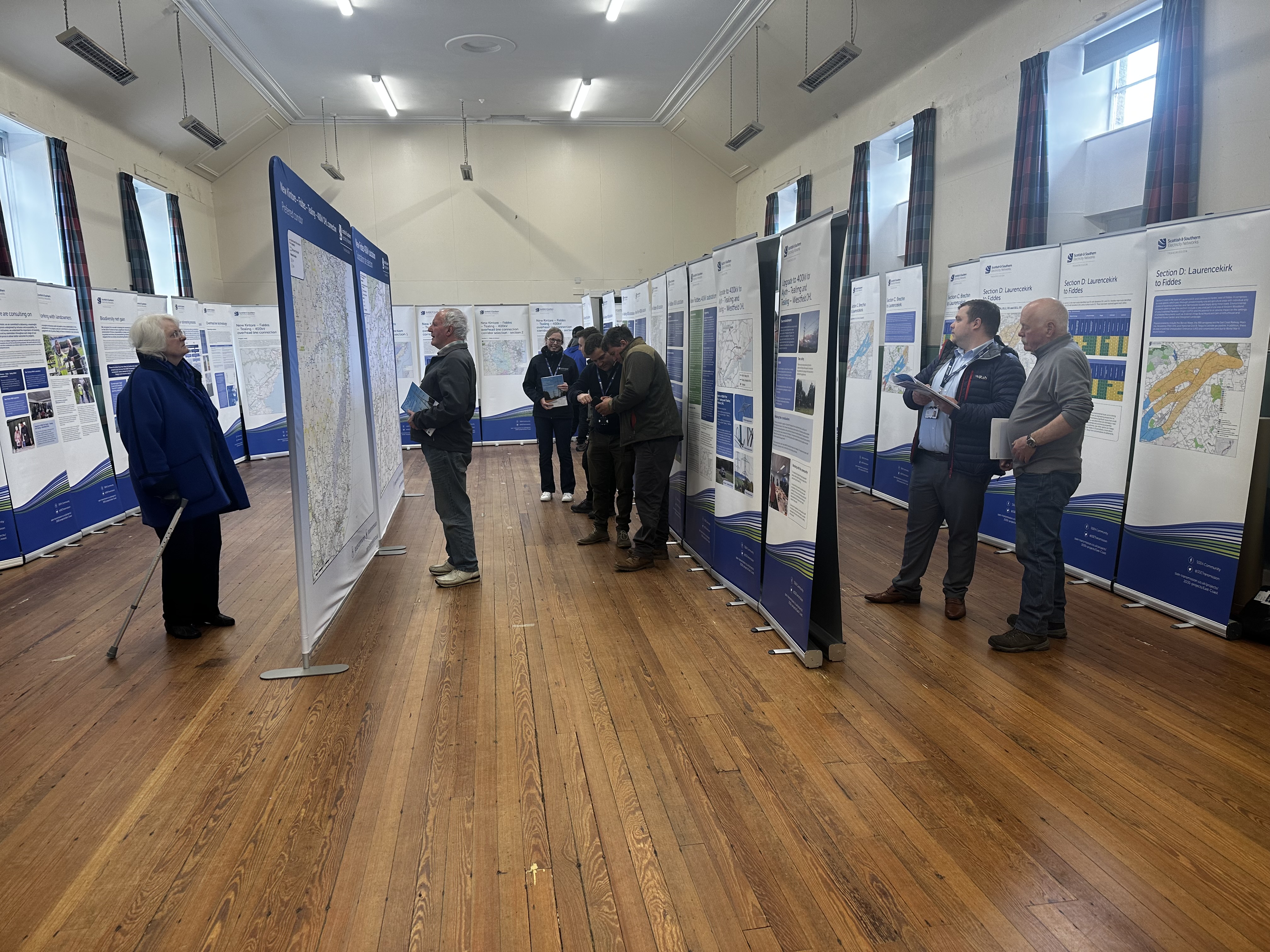
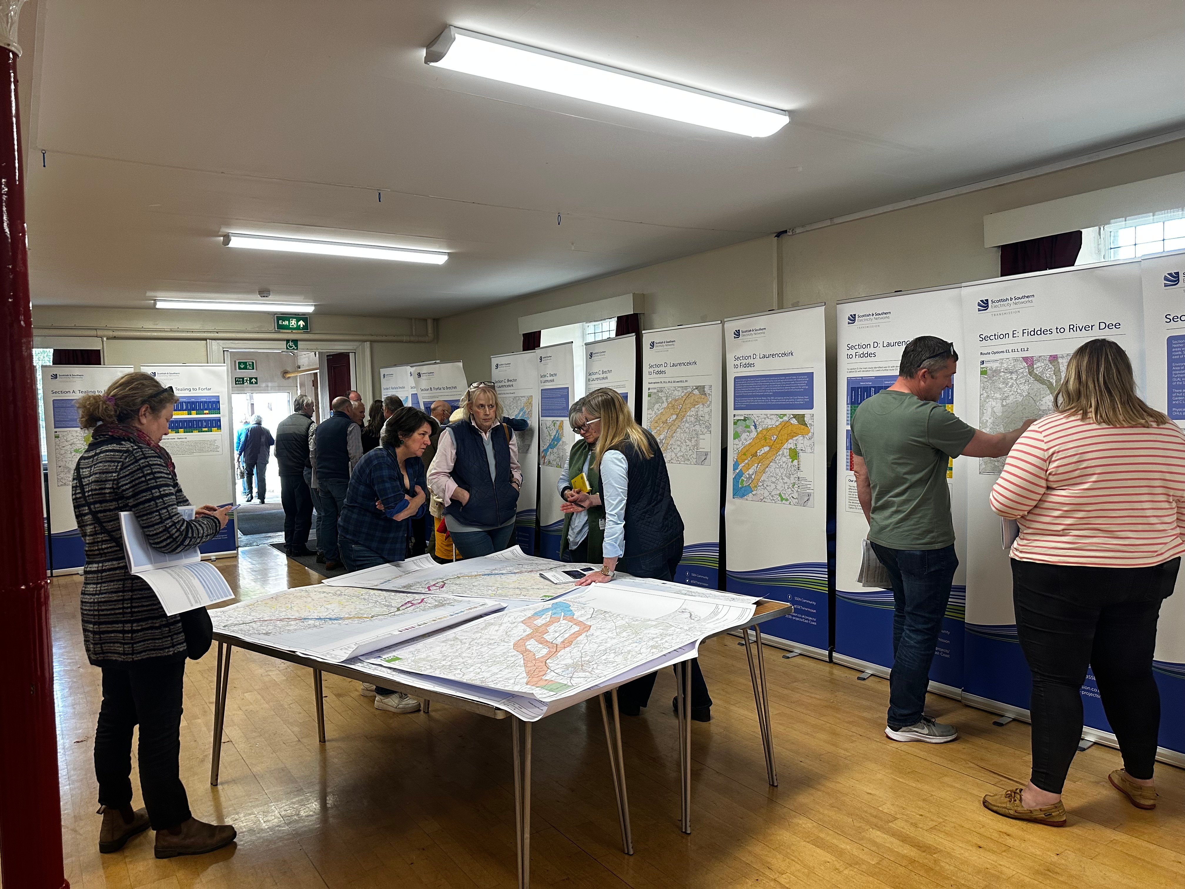
Our Reports on Consultation across our three new overhead line projects and associated substation and convertor station developments have now been published. These reports provide a summary of the extensive feedback received during consultation, how this has been considered and confirmation of which routes and substations are now being taken forward to the next stage of development.
Our Reports on Consultation are now available to download from the Project Documentation tab.
Summary Reports on Consultation are also available for each of the three schemes and can be downloaded below:
- Summary Report on Consultation Beauly to Peterhead
- Summary Report on Consultation Spittal to Beauly
- Summary Report on Consultation Kintore to Tealing
A stakeholder webinar available for all to join will be held in the coming weeks to share the changes informed by the feedback. More information about the forthcoming webinar will be shared on our events page shortly.
In further recognition of community feedback, we will seek to rationalise cumulative infrastructure impacts through the removal and undergrounding of existing transmission lines, where technically practical and appropriate, and subject to all necessary planning consents and landowner agreements.
Work to identify and assess potential sections of existing overhead line where their removal will reduce cumulative impacts is ongoing, with an update expected as part of the next round of public consultation on overhead line alignments and more detailed substation designs in early 2024.
We would once again like to thank all stakeholders who took the time to engage with our early consultation process. We will continue to engage with stakeholders ahead of consulting further with local communities and stakeholders in the new year, as we look to refine our proposals.
-
Report on Consultation
Over the course of this year, we have undertaken extensive consultation on plans to upgrade the electricity transmission network across the north of Scotland and have received a considerable amount of feedback from a wide range of stakeholders regarding our proposals.
We recently advised in our next steps for 2030 network developments update that following assessment of consultation feedback and additional options analysis, we would publish our Report on Consultations (RoCs). These reports provide a summary of the feedback received and how it has been considered, which options we will take forward to the next stage of the development process and any changes to options initially consulted on.
It is our intention to publish the RoCs for this project in the coming months. All stakeholders signed up for updates on the project will receive a link to the report and we will also issue Summary Reports to help ensure accessibility.
These Report on Consultations mark the completion of the first round of non-statutory consultation, where we sought feedback on the corridor, route, and substation locations. We will be consulting further with local communities and stakeholders in the new year, as we look to refine the projects, therefore we welcome an open channel of communication and would like to reassure all stakeholders that there will be further opportunities to engage on this project.
Our Reports on Consultation and Summary Reports on Consultation are now available to download from the Project Documentation tab. -
SSEN Transmission sets out next steps for Pathway to 2030 network developments
We have announced our next steps for our Pathway to 2030 programme of projects. We would like to thank everyone who has engaged with our teams and kindly taken the time to respond to our consultations.
Full details of the announcement can be found here:
Next steps for Pathway to 2030 -
Survey works to help inform next stages of development
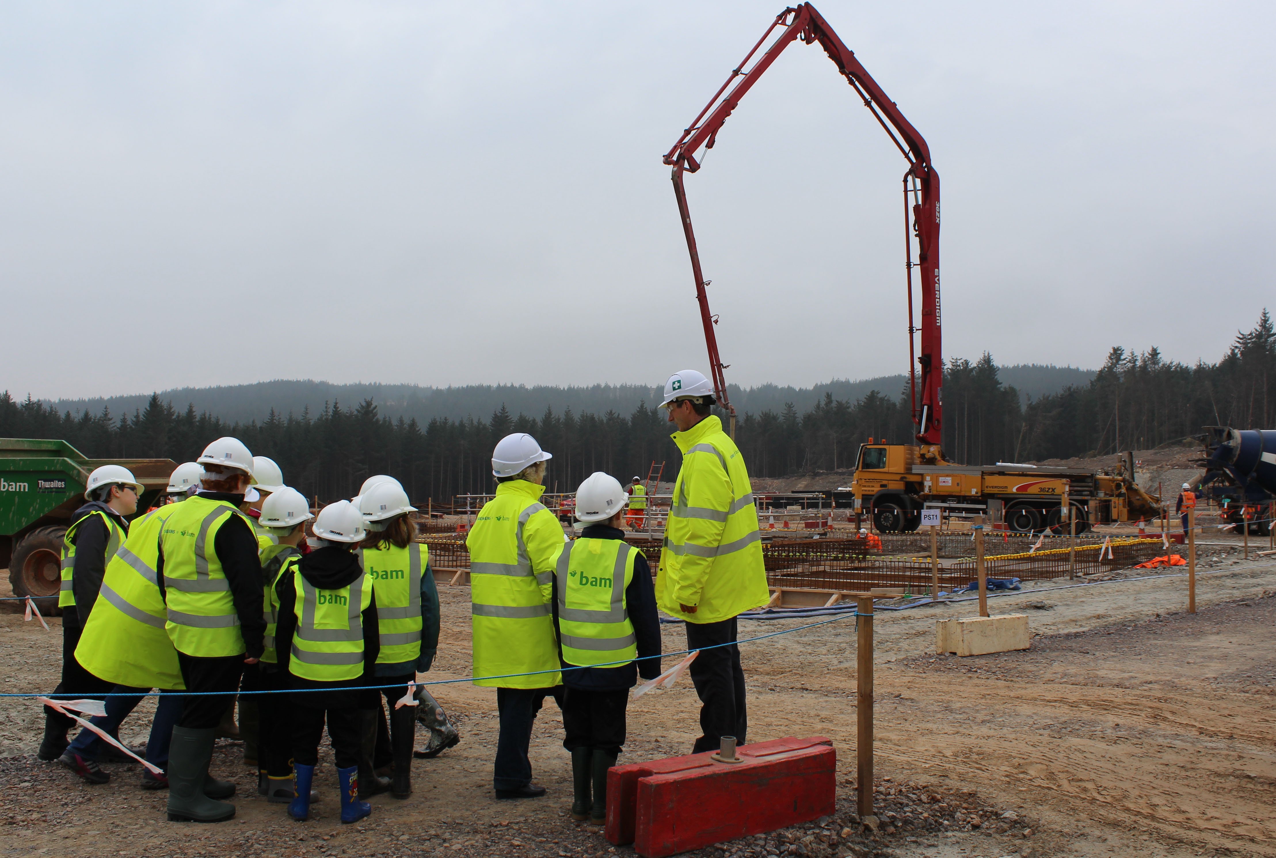
We have recently started localised surveys, assessments and ground investigation works at various locations across the Pathway to 2030 projects which will be used to help gather information to inform the next stage of development for a major electricity transmission network upgrade in the north of Scotland.
Over the coming weeks and months, our project teams and contractors will undertake a series of site-specific assessments which include the likes of ground investigations, bird surveys, LiDAR flights, and ecological and archaeological walkovers and assessments.
Ground investigation works have either recently commenced or are set to begin throughout the Summer for the new 400kV substation and converter stations proposed as part of our Spittal – Loch Buidhe – Beauly 400kV connection, Western Isles connection, Beauly – Blackhillock – New Deer – Peterhead 400kV connection and East Coast 400kV phase 2 projects. Project teams and contractors will undertake a series of site-specific assessments which will help provide vital information and key data for the next phase of project development.
Some of the geo-technical ground investigations may involve drilling boreholes or digging trial pits, which will allow engineers to understand the geographical make-up and suitability of the ground in certain locations to help inform potential design options.
Site assessments and survey works are a key part of the project development process, and the results of these investigations will provide project teams with valuable information to help inform decisions regarding substation site selections and overhead line routes, which will be subject to further consultation later this year.
Initial surveys will prioritise sites and routes which performed the best based on our initial assessment of key environmental and people, technical, and economic factors, and there have been no decisions taken on locations as yet.
There may be more activity on the ground over the summer, and whilst most assessments are expected to cause very little local disruption, we would like to thank the local community for their patience whilst they are carried out. Where more evasive assessments are required such as ground investigation works, we will work to keep local disruption and environmental impacts to a minimum. Please contact your local Community Liaison Manager if you have any questions.
-
Public consultation feedback period has now closed
We would like to thank all stakeholders who took the time to attend and respond to our recent public consultation regarding our identified route options and substation locations for the new Spittal – Loch Buidhe – Beauly 400kV Connection project.
The in-person consultation events were held between 20th February and 6th March at 9 different locations between Halkirk and Beauly and supplemented with an online event. The consultation feedback period was extended by two weeks and closed on 14th April.
Our proposals received a particularly high level of interest with over 600 online feedback forms received and a large volume of email and letter feedback.
We look forward to engaging further with local communities and stakeholders as we begin detailed analysis on the feedback received and carrying out more targeted engagement to assist with refining proposals. Our next public consultation event is currently scheduled for late 2023.
In the meantime, a Consultation Summary Report and a Frequently Asked Questions document will be published in the coming weeks.
Public Consultation February - March 2023
Public consultation feedback period has now closed
We would like to thank all stakeholders who took the time to attend and respond to our public consultation regarding our identified route options and substation locations for the new Spittal – Loch Buidhe – Beauly 400kV Connection project.
The in-person consultation events were held between 20th February and 6th March at 9 different locations between Halkirk and Beauly and supplemented with an online event. The consultation feedback period was extended by two weeks and closed on 14th April.
Our proposals received a particularly high level of interest with over 600 online feedback forms received and a large volume of email and letter feedback.
We look forward to engaging further with local communities and stakeholders as we begin detailed analysis on the feedback received and carrying out more targeted engagement to assist with refining proposals, as well as a further consultation event.
A Consultation Summary Report can be found in the Project Documents tab on this webpage.
-
Story Map
Our digital story maps provide the detail included within our public consultation events.
This story map outlines the new Beauly area 400kV substation and HVDC converter station and includes an interactive map of the proposed sites.Beauly area 400kV substation and HVDC converter station Story Map
Virtual Public Consultation Event - 6th March 2023
Enter Virtual Exhibition Room
Join us on Monday 6th March 2023 from 5pm - 7pm for our live Virtual Consultation event.
-
Public Consultation - Feb/March 2023
We will be holding an initial drop-in public consultation events in March (see details in the image below) to share our approach to developing this project and the rationale behind our early proposals in the Beauly area.
Through carrying out site selection surveys we have been able identify suitable locations for the new substation, including the identification of a preferred substation site. Our preferred site location has been selected based on being technically feasible, economically viable, and could be anticipated to cause the least disturbance to the environment and to those who live, work, and visit the area.
We are keen to hear your feedback regarding the preferred site, and if there are further considerations you believe need to be taken in to account during the next stage of the development process.
The consultation events will be taking place on:
20th February (2.30–7pm) - Halkirk, Ross Institue
21st February (2.30–7pm) - Helmsdale, Bunilidh Social Club
22nd February (2.30–7pm) - Dunbeath, Dunbeath Hall
23rd February (2.30–7pm) - Golspie, Fountain Road Hall
27th February (3.30–7pm) - Bonar Bridge, Community Hall
28th February (2.30–7pm) - Ardross, Community Hall
1st March (2.30–7pm) - Dingwall – Legion Hall
2nd March (2.30–7pm) - Beauly – Kilmorack Hall
6th March (5–7pm) Virtual event (Joining details to follow on website)
Should you have any questions regarding the consultations please contact the Community Liaison Manager, Martin Godwin.
Documents
Planning Application - Supplementary Information - Oct 2025
Planning Application - EIA Report Volume 1 Non Technical Summary
Planning Application - EIA Report Volume 2: Main Report
Planning Application - EIA Report Volume 3: Figures
Planning Application - EIA Report Volume 4: Appendices
Planning Application - EIA Standalone Documents
Planning Application – Planning Statement
Planning Application – Planning Drawings
Planning Application – Design and Access Statement
Information Sessions February 2025
-
Proposed Fanellan project updates - February 2025
- Type:
- Date:
- 23 June 2025
- Size:
- 2 MB
Pre-Application Consultation Documents 2 (PAC2) - June 2024
-
Connections into Fanellan and Permanent Requirements Layout Plan
- Type:
- Date:
- 10 June 2024
- Size:
- 2.7 MB
These maps provide information to our stakeholders about the connections into the proposed Fanellan site and the Fanellan permanent requirements layout plan for the site.
-
Western Isles handout
- Type:
- Date:
- 06 June 2024
- Size:
- 6.7 MB
This material provides information to our stakeholders about the Western Isles Connection into Fanellan Converter Station.
-
Fanellan temporary requirements layout
- Type:
- Date:
- 06 June 2024
- Size:
- 950.8 KB
This map provides information to our stakeholders about the Fanellan temporary requirements layout plan for the site.
-
Fanellan Consultation Poster
- Type:
- Date:
- 06 June 2024
- Size:
- 105 KB
This material provides information to our stakeholders about the project and consultation events in June 2024.
-
Fanellan Consultation Banners
- Type:
- Date:
- 06 June 2024
- Size:
- 7 MB
This material provides information to our stakeholders about the project.
-
Fanellan Consultation Booklet
- Type:
- Date:
- 06 June 2024
- Size:
- 25.5 MB
This Pre-Application Consultation Booklet (and associated appendices/maps) explains the project need and summarises the process which has been followed to arrive at the optimal site. It forms part of the consultation exercise which provides all interested parties with the opportunity to provide feedback.
Pre-Application Consultation Documents (PAC)
-
Feedback Event Poster - Jun 2024
- Type:
- Date:
- 03 June 2024
- Size:
- 105 KB
This material provides information to our stakeholders about the project and consultation events in June 2024.
-
Western Isles Connection Handout
- Type:
- Date:
- 18 March 2024
- Size:
- 6.7 MB
This material provides information to our stakeholders about the Western Isles Connection into Fanellan Converter Station.
-
Fanellan red line boundary with permanent site requirements, February 2024
- Type:
- Date:
- 14 March 2024
- Size:
- 19.4 MB
This map provides information to our stakeholders about the Proposal of Application Notice (PAN) red line boundary for the site.
-
Beauly Area Pathway to 2030 projects overview
- Type:
- Date:
- 14 March 2024
- Size:
- 2.2 MB
This map provides information to our stakeholders about connections into the proposed Fanellan site.
-
Proposal of application boundary map showing indicative permanent requirments
- Type:
- Date:
- 14 March 2024
- Size:
- 3.2 MB
This map provides information to our stakeholders about the Proposal of Application Notice (PAN) boundary map showing indicative permanent requirements.
-
Fanellan poster
- Type:
- Date:
- 13 March 2024
- Size:
- 69.1 KB
This material provides information to our stakeholders about the project and consultation events in June 2024.
-
Overview of environmental features and designations in the wider area
- Type:
- Date:
- 13 March 2024
- Size:
- 5.3 MB
This map provides information to our stakeholders with an overview of environmental features and designations in the wider area.
-
Fanellan Consultation Banners
- Type:
- Date:
- 13 March 2024
- Size:
- 9.2 MB
This material provides information to our stakeholders about the project.
-
Fanellan Consultation Booklet
- Type:
- Date:
- 13 March 2024
- Size:
- 16.5 MB
This Pre-Application Consultation Booklet (and associated appendices/maps) explains the project need and summarises the process which has been followed to arrive at the optimal site. It forms part of the consultation exercise which provides all interested parties with the opportunity to provide feedback.
Additional Information
Project Documents
-
Beauly Community Council meeting slidepack May 2025 -Slides 12 &13.pdf
- Type:
- Date:
- 25 August 2025
- Size:
- 3.4 MB
Beauly Community Council meeting slidepack May 2025 -Slides 12 &13 amended to provide clarity and fuller explanation about Beauly/Black Bridge traffic movements. Note HGV movement in any direction.
-
Beauly Community Council Meeting Q&A May 2025
- Type:
- Date:
- 30 June 2025
- Size:
- 2 MB
This document provides answers to the questions put to members of SSEN Transmission Fanellan project team before and during the Beauly Community Council public meeting held on 26th May 2025.
-
Fanellan Traffic Management FAQ - March 25
- Type:
- Date:
- 24 May 2025
- Size:
- 1.2 MB
This document was written in response to local enquiries regarding intended traffic management plans relating to the Fanellan project
-
Nov 23 CLG Project updates and Meeting Notes
- Type:
- Date:
- 14 December 2023
- Size:
- 2.7 MB
-
Nov 23 CLG RoC preview Summary and Meeting Notes
- Type:
- Date:
- 14 December 2023
- Size:
- 2.7 MB
-
Beauly CLG - Beauly Substation Workshop - Nov 23
- Type:
- Date:
- 05 December 2023
- Size:
- 2.2 MB
-
Aug CLG meeting notes Final
- Type:
- Date:
- 23 November 2023
- Size:
- 8.7 MB
-
Beauly 400kV Substation Hub_Site Selection_Consultation Document Sep 2023
- Type:
- Date:
- 05 October 2023
- Size:
- 5 MB
-
Final Beauly CLG Meeting Notes June 2023
- Type:
- Date:
- 07 September 2023
- Size:
- 3.3 MB
-
Beauly CLG Meeting Notes April 2023
- Type:
- Date:
- 27 July 2023
- Size:
- 2.1 MB
-
Beauly CLG Meeting Notes Feb 2023
- Type:
- Date:
- 27 July 2023
- Size:
- 1.3 MB
-
Beauly CLG Meeting Notes November 2022
- Type:
- Date:
- 27 July 2023
- Size:
- 852.8 KB
-
Beauly CLG Meeting Notes August 2022
- Type:
- Date:
- 27 July 2023
- Size:
- 1.1 MB
-
Consultation Report - Spittal - Loch Buidhe - Beauly - July 23
- Type:
- Date:
- 13 July 2023
- Size:
- 1.3 MB
-
Spittal - Beauly Consultation response May 2023
- Type:
- Date:
- 17 May 2023
- Size:
- 166.2 KB
-
Spittal-Loch Buidhe-Beauly initial consultation feedback response 28.03.23
- Type:
- Date:
- 28 March 2023
- Size:
- 199.9 KB
-
Beauly Main Site Options Map with Legend
- Type:
- Date:
- 01 March 2023
- Size:
- 70.5 MB
-
Consultation Booklet new Beauly Area site Selection and Spittal - Beauly OHL route
- Type:
- Date:
- 17 February 2023
- Size:
- 67.3 MB
-
Public Consultation Poster - Feb/March 2023
- Type:
- Date:
- 06 February 2023
- Size:
- 101 KB
Reports on Consultation
-
RoC - New Beauly Area 400kV Substation - Figure 2 - Proposed Site
- Type:
- Date:
- 01 December 2023
- Size:
- 1.6 MB
-
Report on Consultation - Beauly to Blackhillock to New Deer to Peterhead 400kV OHL
- Type:
- Date:
- 01 December 2023
- Size:
- 2.3 MB
-
Summary ROC - Spittal to Beauly
- Type:
- Date:
- 01 December 2023
- Size:
- 4.8 MB
-
Summary ROC - Beauly to Peterhead
- Type:
- Date:
- 01 December 2023
- Size:
- 2.8 MB
-
RoC - Beauly - Peterhead OHL - Figure 4.10 Proposed Route to be taken to Alignment
- Type:
- Date:
- 01 December 2023
- Size:
- 5.8 MB
-
RoC - Beauly - Peterhead OHL - Figure 1.1 - Route Options Shared at Consultations
- Type:
- Date:
- 01 December 2023
- Size:
- 10.6 MB
-
RoC - Beauly - Peterhead OHL - Preferred Route with Amendments
- Type:
- Date:
- 01 December 2023
- Size:
- 14.1 MB
-
RoC - Beauly to Spittal OHL - Figure 1 - Route Options Presented at Consultation
- Type:
- Date:
- 01 December 2023
- Size:
- 6.7 MB
-
RoC - Beauly to Spittal OHL - Figure 2 - Proposed Route options to take forward to alignment phase
- Type:
- Date:
- 01 December 2023
- Size:
- 6.1 MB
-
Report on Consultation - Spittal to Loch Buidhe to Beauly Overhead Line
- Type:
- Date:
- 01 December 2023
- Size:
- 3.2 MB
-
Report on Consultation - Beauly to Blackhillock to New Deer to Peterhead 400kV OHL
- Type:
- Date:
- 01 December 2023
- Size:
- 3.9 MB
FAQs
Who we are
About the Pathway to 2030 projects
Our approach to routeing and public consultation
Environmental considerations
Community and landowner considerations
Cost and engineering considerations
Recite me
To make use of this function please click on the 3 'A's' button at the bottom left of the website.

Latest Links
-
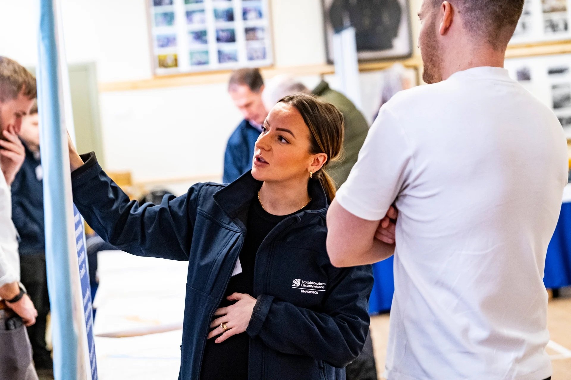
Report on Consultation
Our Reports on Consultation across our three new overhead line projects and associated substation and convertor station developments have now been published. These reports provide a summary of the extensive feedback received during consultation, how this has been considered and confirmation of which routes and substations are now being taken forward to the next stage of development.
Our Reports on Consultation are now available to download from the Project Documentation tab.
Summary Reports on Consultation are also available for each of the three schemes and can be downloaded below:
- Summary Report on Consultation Spittal to Beauly
- Summary Report on Consultation Beauly to Peterhead
- Summary Report on Consultation Kintore to Tealing
A stakeholder webinar available for all to join will be held in the coming weeks to share the changes informed by the feedback. More information about the forthcoming webinar will be shared on our events page shortly.
In further recognition of community feedback, we will seek to rationalise cumulative infrastructure impacts through the removal and undergrounding of existing transmission lines, where technically practical and appropriate, and subject to all necessary planning consents and landowner agreements.
Work to identify and assess potential sections of existing overhead line where their removal will reduce cumulative impacts is ongoing, with an update expected as part of the next round of public consultation on overhead line alignments and more detailed substation designs in early 2024.
We would once again like to thank all stakeholders who took the time to engage with our early consultation process. We will continue to engage with stakeholders ahead of consulting further with local communities and stakeholders in the new year, as we look to refine our proposals.
-
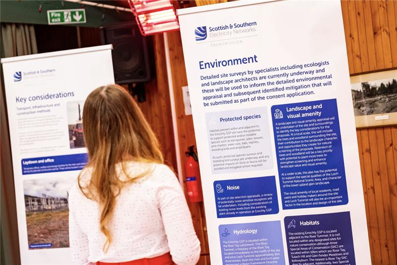
Report on Consultation
Over the course of this year, we have undertaken extensive consultation on plans to upgrade the electricity transmission network across the north of Scotland and have received a considerable amount of feedback from a wide range of stakeholders regarding our proposals.
We recently advised in our next steps for 2030 network developments update that following assessment of consultation feedback and additional options analysis, we would publish our Report on Consultations (RoCs). These reports provide a summary of the feedback received and how it has been considered, which options we will take forward to the next stage of the development process and any changes to options initially consulted on.
It is our intention to publish the RoCs during the week commencing 27 November. All stakeholders signed up for updates on the project will receive a link to the report and we will also issue Summary Reports to help ensure accessibility.
These Report on Consultations mark the completion of the first round of non-statutory consultation, where we sought feedback on the corridor, route, and substation locations. We will be consulting further with local communities and stakeholders in the new year, as we look to refine the projects, therefore we welcome an open channel of communication and would like to reassure all stakeholders that there will be further opportunities to engage on this project.
Our Reports on Consultation and Summary Reports on Consultation are now available to download from the Project Documentation tab. -
SSEN Transmission sets out next steps for Pathway to 2030 network developments
We have announced our next steps for our Pathway to 2030 programme of projects. We would like to thank everyone who has engaged with our teams and kindly taken the time to respond to our consultations.
Full details of the announcement can be found here:
Next steps for Pathway to 2030